Alberto bringing rain, wind, flooding
Published 9:49 am Monday, May 28, 2018
- Alberto
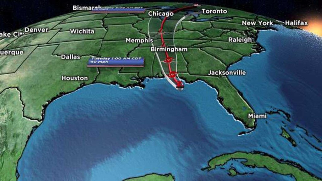
THE LATEST: Bands of rain are already lifting into the area from the southeast as Alberto moves closer to the Gulf Coast. The system will make a landfall by early afternoon near Panama City and gradually weaken as it moves inland. This is a very large storm with bands of rain extending well north and east of the center. So on and off tropical downpours will impact our area throughout the day, with the possibility of isolated thunderstorms.
TIMING: While rainy periods can be expected this morning, and throughout the day, a steadier rain will set in tonight as Alberto moves north and across our area. The primary impacts from this system will linger into late Tuesday morning, with rain decreasing in coverage Tuesday afternoon and evening.
WHAT TO EXPECT AND IMPACTS: Rain amounts may exceed 3 to 4 inches in some areas between now and tomorrow, making localized flooding the primary threat. Wind speeds will increase to 10 to 20 mph late tonight out of the east as the system moves inland, with gusts possibly topping 30 mph. The system will be weakening into a depression so maximum sustained winds in our area will remain below 39 mph. The higher wind gusts are projected to impact areas along and east of the I-65 corridor so if you live in these zones, it would be a good idea to make sure loose outdoor items are secure. There will be a marginal risk for brief spin-up tornadoes over our eastern counties. So stay weather alert for possible warnings this evening and overnight. If you’re monitoring radar on the Weather App, pay close attention to any heavier rain bands east of the center. These are typically the favorable areas for tropical related tornadoes. Again, the threat is low but it is worth monitoring overnight as Alberto impacts our area.
PLANNING: If you have an outing planned for the day you may catch some breaks but be aware rain could begin at any time. If storms develop we will always have the risk of cloud to ground lightning and be aware that rain chances will only go up later today. It is going to remain quite moist and muggy and the ground is going to remain rather wet so it won’t be the best day for mowing the lawn. I would also try to get the grill started prior to lunchtime if you have plans to break out the charcoal. Our team at WBRC plans on providing plenty of updates throughout the day on-air and online. We also have teams stationed along the Gulf Coast and we will provide updates as this system makes landfall.
