Weather update: Afternoon storm outlook is ominous for central Alabama
Published 2:52 pm Tuesday, April 29, 2014
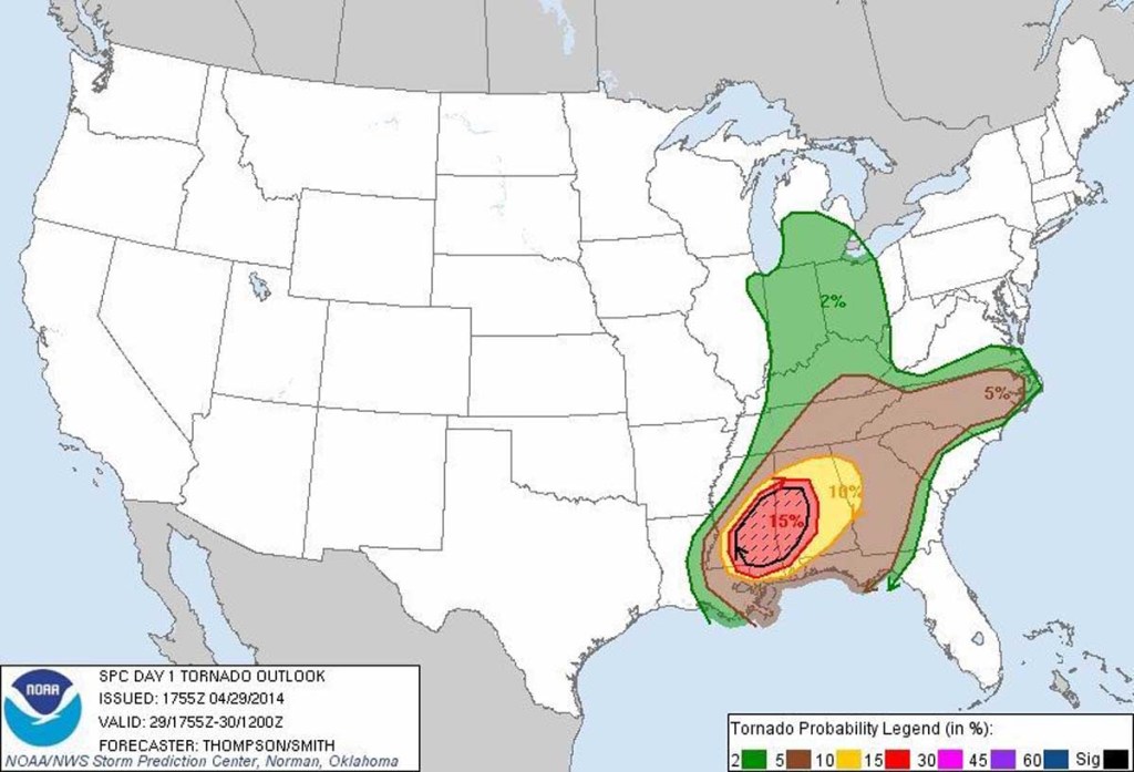
- The afternoon tornado outlook for Tuesday, April 29 shows a 15 percent chance of a tornado striking within 25 miles of any given point within the rad-shaded area, which includes much of central Alabama. The cross-hatched area indicates an enhanced likelihood of tornadoes rated EF2 or stronger on the Enhanced Fujita scale.
The National Weather Service has updated its outlook for severe weather in central Alabama for this afternoon, and it isn’t encouraging.
A large portion of the state remains under a moderate risk for severe weather for the rest of today. The NWS Storm Prediction Center has also issued a tornado outlook that gives a 15 percent probability that a tornado will occur within 25 miles of any given point within a large portion of west and central Alabama. Additionally, a portion of that area has an enhanced risk of strong tornadoes rated EF-2 or worse on the Enhanced Fujita scale.
The sunshine and rising temperatures we have experienced since this morning are actually a bad sign, as the sun warms up the atmosphere and makes it more unstable. That turns into fuel that helps spawn severe thunderstorms and tornadoes.
The NWS has changed the expected arrival time for severe weather in metro Birmingham as well. Instead of 3 p.m. as forecast earlier, the severe weather is now expected to arrive between 5 and 7. This is also problematic for two reasons: the atmosphere has more time to heat up, and tornadoes have a better chance of developing after dark when they are much harder to see.
Already storms are starting to form rapidly in southern Mississippi, which is the starting point for today’s “train” of storms.
As for last night’s weather, a team from the National Weather Service has confirmed that a tornado struck Kimberly and have rated it an EF-1 scale. The path was 3.3 miles long, and 800 yards (almost half a mile) at its widest point.